Hi, guys!
By looking at the title, you can tell that I have GREAT NEWS! Apparently, Google has been looking at my blog, and discovered that I uncovered a lot of information while on the job. They have decided to add a job title to my current job (photographing for Google Earth) which is learning more about tectonic plates. Some would dread this, but tectonic plates are really interesting to me! Plus, this means more cash.. hehehehe
Unfortunately, I don't know whether or not if I will continue this blog due to the extra work I'm doing. However, sometime in the near future, look for my name in science newsletters and such.
Great times with you guys!
-Giant Aardvarks
Sunday, April 10, 2011
Wednesday, April 6, 2011
Hmm hmm hmm
I have been travelling for a while.. so I'm just going to stop and rest for a bit.. I'm pretty tired from going all across the globe, but it was still funnn! Sorry there's nothing interesting to report.. (almost as interesting as my job...)
heres a picture of an aardvark :)

http://cdn2.digitaltrends.com/wp-content/uploads/2010/02/aardvark.jpg
Well, after I rest up, anyone who leaves me a comment saying where they want me to go, I might go!
mehhhhhhh
Peace outt
heres a picture of an aardvark :)
http://cdn2.digitaltrends.com/wp-content/uploads/2010/02/aardvark.jpg
Well, after I rest up, anyone who leaves me a comment saying where they want me to go, I might go!
mehhhhhhh
Peace outt
G'day, New Zealzzzz
So cool to be in a country that has the letter "Z" in its name! I am on the private Google Cruise on my way to New Zealandddddd. There, I'll be in Christchurch ( 43°31'55.38"S, 172°38'10.37"E)with Destiny Lockhart to investigate the earthquake that occurred on Feb 22. Maybe I should just ask Google if I can also be a tectonic plate boundary detective as well as a Google Earth van driver.. great job I have..
Ok, I'm looking at the info + details.. It was a 6.3 magnitude earthquake. This was a divergent movement, which means the motion was moving apart. However, this boundary line doubles as both a divergent AND transform boundary.

http://www.gweaver.net/techhigh/projects/period1_2/Yellowstone/Images/Divergent%20Boundary.jpg
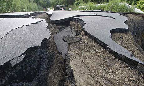
these are some photos.. of kids playing with crack.

https://blogger.googleusercontent.com/img/b/R29vZ2xl/AVvXsEh3sdfW-Q7PDTXzYP2VhFI0J96ENBcgng1uLlDwE3QatoCGxlslLom_u2UuHIIYdEc55M-ET2GeFu9FF7hfp2qcsVSnON4BuNT6wKFCQIlbzDcl1FynBN9U2D3puzTS3QE8dG8kS6MZO8g/s1600/ChristchurchEarthquake.jpg
Volcanoes have been forming, some sources say. There are also continuous aftershocks, so I wouldn't recommend that you hang out in the cracks like these kids!
One interesting thing I found is the mountain range next to the boundary line. No surprise thereee!
Also, last year on September 4th, there was a 7.1 earthquake just like the most recent one. However, it was only shaking, and did not have direct damage toward Christchurch.
I'll be chilling like villain with Destiny Lockhart.. She's a cool bean.
Peace outttt
Ok, I'm looking at the info + details.. It was a 6.3 magnitude earthquake. This was a divergent movement, which means the motion was moving apart. However, this boundary line doubles as both a divergent AND transform boundary.
http://www.gweaver.net/techhigh/projects/period1_2/Yellowstone/Images/Divergent%20Boundary.jpg
these are some photos.. of kids playing with crack.
https://blogger.googleusercontent.com/img/b/R29vZ2xl/AVvXsEh3sdfW-Q7PDTXzYP2VhFI0J96ENBcgng1uLlDwE3QatoCGxlslLom_u2UuHIIYdEc55M-ET2GeFu9FF7hfp2qcsVSnON4BuNT6wKFCQIlbzDcl1FynBN9U2D3puzTS3QE8dG8kS6MZO8g/s1600/ChristchurchEarthquake.jpg
Volcanoes have been forming, some sources say. There are also continuous aftershocks, so I wouldn't recommend that you hang out in the cracks like these kids!
One interesting thing I found is the mountain range next to the boundary line. No surprise thereee!
Also, last year on September 4th, there was a 7.1 earthquake just like the most recent one. However, it was only shaking, and did not have direct damage toward Christchurch.
I'll be chilling like villain with Destiny Lockhart.. She's a cool bean.
Peace outttt
Hello Seattle~~~
I did Google Earth picture recording at Sendai, and all I can say is I'm lucky to be alive and well! Right now, I am back in Seattle (47'24'57" N 122'20'09" W) after taking the private Google Earth plane (AWESOME!!!) and staying with family. However, I don't have much to do in Seattle except work (drive around in maaa sweet ridee) which is kind of dull. I remember that in 2001, Seattle had the Nisqually Earthquake which was a 6.8 (pretty big for the Seattle- metro area!) Luckily, our buildings were built well to handle the earthquakes.


After some research (of course on my Google Android phone), I learned that the Juan De Fuca Plate subducted under the North American Plate, raising it up, causing the earthquake. This region usually has deep earthquakes. There are also the Cascade Mountain Ranges and Mt. St. Helens.
http://www.dnr.wa.gov/SiteCollectionImages/Places/ger_nis_quake01.jpg
Also, a little bit afterwards I went out into the ocean and looked for the boundary lines. I was surprised to see that this was a transform tectonic boundary line as well as a subduction. WOW!!!!
Location of the transform boundary line + trench: 43°46'31.56"N 128°37'47.58"W
Also, a little bit afterwards I went out into the ocean and looked for the boundary lines. I was surprised to see that this was a transform tectonic boundary line as well as a subduction. WOW!!!!
Location of the transform boundary line + trench: 43°46'31.56"N 128°37'47.58"W
Tuesday, April 5, 2011
On my way to Sendai!
Hi all,
I am in the car, and I am on my way to Sendai and Fukushima. I landed at Narita International Airport, and i have to take a long drive all the way to Sendai. The airport in Sendai was completely wiped out.... sad..
I am on my way to the island of Honshu, and currently I am about to get off the mainland.
I can already see the signs of devastation around here. There are cracks in the streets here and there, and I'm terrified of what's to come. Also, on March 13, there was an eruption of Mt. Shinmoedake on the island of Kyuushu. I'm not very sure if each these are related, but they sure are scary.
On a debrief about this trip, I learned that Japan is one of the most seismically active places on the planet. The reason is because Japan lies near the meeting of the Pacific, Philippine, and Eurasian plates. Now, what happened in the earthquake is that the Pacific plate when under the Eurasian plate. This movement is called subduction. This pushed the Eurasian plate up, causing the earthquake. Now, since Japan is right where they meet, they got most of the trouble. This resulted in tsunamis that was another major concern for Japan and other countries.
http://oceanexplorer.noaa.gov/explorations/06fire/background/volcanism/media/subducting_plate_600.jpg
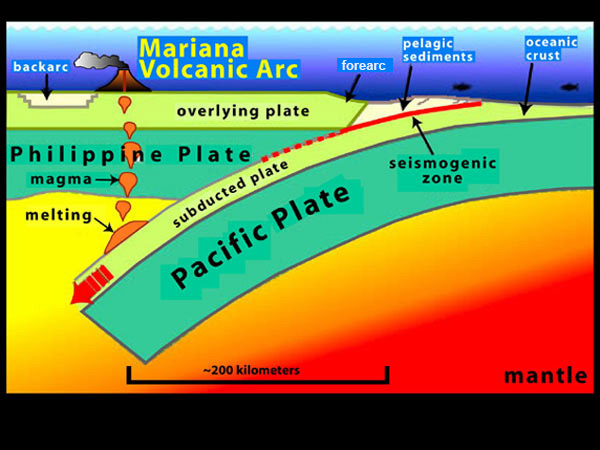
This is a perfect diagram of what happened. Also, in this picture, you read something about a Mariana trench. This is the result of subduction boundary between the Philippine and Pacific plate. Later, I am heading to where the damage is at the most; the ocean. I'm looking into visiting 37'43'45" N 143' 50' 17" E. This is a convergent tectonic boudnary, which means they are coming into each other.
http://static.guim.co.uk/sys-images/Guardian/Pix/pictures/2008/06/14/japanb276.jpg
just some pictures i found on the way!
ttyl, Matthew
I am in the car, and I am on my way to Sendai and Fukushima. I landed at Narita International Airport, and i have to take a long drive all the way to Sendai. The airport in Sendai was completely wiped out.... sad..
I am on my way to the island of Honshu, and currently I am about to get off the mainland.
I can already see the signs of devastation around here. There are cracks in the streets here and there, and I'm terrified of what's to come. Also, on March 13, there was an eruption of Mt. Shinmoedake on the island of Kyuushu. I'm not very sure if each these are related, but they sure are scary.
On a debrief about this trip, I learned that Japan is one of the most seismically active places on the planet. The reason is because Japan lies near the meeting of the Pacific, Philippine, and Eurasian plates. Now, what happened in the earthquake is that the Pacific plate when under the Eurasian plate. This movement is called subduction. This pushed the Eurasian plate up, causing the earthquake. Now, since Japan is right where they meet, they got most of the trouble. This resulted in tsunamis that was another major concern for Japan and other countries.
http://oceanexplorer.noaa.gov/explorations/06fire/background/volcanism/media/subducting_plate_600.jpg
This is a perfect diagram of what happened. Also, in this picture, you read something about a Mariana trench. This is the result of subduction boundary between the Philippine and Pacific plate. Later, I am heading to where the damage is at the most; the ocean. I'm looking into visiting 37'43'45" N 143' 50' 17" E. This is a convergent tectonic boudnary, which means they are coming into each other.
http://static.guim.co.uk/sys-images/Guardian/Pix/pictures/2008/06/14/japanb276.jpg
just some pictures i found on the way!
ttyl, Matthew
Monday, April 4, 2011
NEPAL EARTHQUAKKEEE!! SCARED!!!
**** UPDATE: A 5.7 EARTHQUAKE HIT THE INDIA - NEPAL BORDER (SUPER NEAR TO WHERE I AM!!)
29°42'18.30"N 80°48'50.91"E Divergent Boundary Line
I felt the tremors! I felt them! Currently, I am right above the epicenter even though I REALLY don't want to be here! I was driving beside the Himalayas in Nepal, but I felt it, and continued to drive the other way. EXCEPT, the Google HQ called to tell me to stop being a wussy, and check the place out. I hate my job....... Apparently, the damage hit all the way to New Delhi, but I don't know if there is any structural damage.
I found this article too... super crazy! http://www.google.com/hostednews/afp/article/ALeqM5h-gVo-zrrNc-SCIxXOBX1rTessHg
"Geologists say it is only a matter of time before a major earthquake hits Nepal's densely populated capital Kathmandu, where 2.5 million people live in cramped, poorly-built housing with little or no awareness of the dangers."
This was written only a year ago on Feb 9, 2010. It has been only a month and a year! OMGGGGGGGGG

This was a divergent earthquake, which means that the land split apart from each other. There are currently some reported volcanoes, but not very serious. There have been little aftershocks as well.. Also, this is common because Nepal is near the Himalayas, which are continuously moving.
http://www.kidsgeo.com/images/divergent-boundary.jpg

This is a simple representation.
29°42'18.30"N 80°48'50.91"E Divergent Boundary Line
I felt the tremors! I felt them! Currently, I am right above the epicenter even though I REALLY don't want to be here! I was driving beside the Himalayas in Nepal, but I felt it, and continued to drive the other way. EXCEPT, the Google HQ called to tell me to stop being a wussy, and check the place out. I hate my job....... Apparently, the damage hit all the way to New Delhi, but I don't know if there is any structural damage.
I found this article too... super crazy! http://www.google.com/hostednews/afp/article/ALeqM5h-gVo-zrrNc-SCIxXOBX1rTessHg
"Geologists say it is only a matter of time before a major earthquake hits Nepal's densely populated capital Kathmandu, where 2.5 million people live in cramped, poorly-built housing with little or no awareness of the dangers."
This was written only a year ago on Feb 9, 2010. It has been only a month and a year! OMGGGGGGGGG
This was a divergent earthquake, which means that the land split apart from each other. There are currently some reported volcanoes, but not very serious. There have been little aftershocks as well.. Also, this is common because Nepal is near the Himalayas, which are continuously moving.
http://www.kidsgeo.com/images/divergent-boundary.jpg
This is a simple representation.
Google Earth Backgroundddd
So, sorry for not introducing myself.
I was already on my job, and wanted to waste no time explaining who I am.
I am a Google Earth worker, which means I spend 24 hours of my day driving in a black van with a camera on the top (which happens to look like a disco globe). It's not as fun as it sounds, believe it or not.
this is maaa ride

http://farm3.static.flickr.com/2004/2445516616_f4ec8794a1.jpg
Well, my hobby is scrolling on my Google Android phone (nerdy, I know) and the topic that's trending on Google News are tectonic plates. Well, I gotta keep up with the "news" and stufffffff...
Well, currently I am flying toward Japan, to photograph the earthquake. Depressing, i know.....
Well, until next time!
I was already on my job, and wanted to waste no time explaining who I am.
I am a Google Earth worker, which means I spend 24 hours of my day driving in a black van with a camera on the top (which happens to look like a disco globe). It's not as fun as it sounds, believe it or not.
this is maaa ride
http://farm3.static.flickr.com/2004/2445516616_f4ec8794a1.jpg
Well, my hobby is scrolling on my Google Android phone (nerdy, I know) and the topic that's trending on Google News are tectonic plates. Well, I gotta keep up with the "news" and stufffffff...
Well, currently I am flying toward Japan, to photograph the earthquake. Depressing, i know.....
Well, until next time!
Subscribe to:
Comments (Atom)